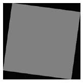
When images are geographically rectified to align accurately with a fixed point (such as magnetic North), the image may appear tilted. Such an image has triangles of transparency along all four edges, as in the following illustration:
When multiple tilted images are seamed together in a mosaic, these transparency triangles often obscure data from adjacent images. This produces an effect similar to the following:
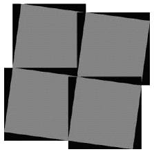
In image mosaics such as this, the black transparency border of some images obscures valid image data in other images.
In order to mosaic these images without data loss, GeoExpress can be instructed to read the transparency areas in the input images as transparent. You can specify a color (or shade of gray) in the input image data to be transparent. The MrSID image produced is seamless, with no loss of data due to transparency borders.
To specify a transparency pixel value, determine the RGB value of the transparency area in the source image. Most commonly, this will be black (0-0-0) or white (255-255-255). If desired, use a color-finder program to read the transparency RGB values. Once the RGB values for the transparency area has been determined, they must be entered manually.
If you have overlapping data, it is recommended that you despeckle the input tiles first or use lossless input images.
For more information see General MrSID Advanced Options .