The Reproject tool changes the projection of an image from one coordinate reference system (CRS) to another.
A coordinate reference system defines the location of a point on a planar or spherical surface. An example familiar to many people is a graph with x and y axes. A geographic coordinate system is a three-dimensional reference system that locates points on the Earth’s surface based on projections. Projections are the method used to display a spherical surface onto a flat surface. In this manner, Cartesian coordinate systems can be overlaid.
Coordinate reference systems are prearranged projections used in specific countries either in modern times or in historical maps. However, many states and counties within a country may employ a different coordinate reference system. These reference systems differ in order to maintain the highest accuracy in a smaller defined region. Because they are only approximations of the shape of the earth – which is irregularly shaped – the larger an area a given coordinate system covers, the less accurate it will be.
An agency working on a broad area of coverage, such as statewide, will typically work in the UTM (Universal Transverse Mercator) system, since it can be used over larger geographic areas. Organizations whose area of interest covers a smaller geography, such as county or city level management, will typically work in a State Plane coordinate system. This presents problems when trying to employ data from different sources for use in a single project.
The reprojection tools in GeoExpress enable you to take images that are georeferenced in one or more coordinate reference systems, and reproject these images to a different coordinate reference system either individually or as a mosaic. CRSs are identified by regions of use, subregions and system names as defined by the European Petroleum Survey Group (EPSG). You can also use well-known text strings (WKTs).
You can repurpose and combine diverse data sets by using the GeoExpress reprojection tools when you create a new image or by reprojecting your existing images. With support for over 2,500 WKT (well-known text) coordinate systems such as State Plane Coordinate Systems and UTM – as well as hundreds of specific regional projections – GeoExpress enables geospatial professionals to share imagery across boundaries previously imposed by disparate coordinate reference systems.
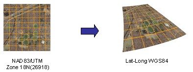
As an example, say you have a shapefile using a coordinate reference system of Latitude/Longitude, WGS84, while the raw imagery you purchased from an image data provider is created in UTM, NAD83, Zone 10N. Using the reprojection feature in GeoExpress, you are able to reproject the raw imagery to the Lat-Long coordinate reference system while converting it to MG3, MG4 or JP2 format within your normal encoding workflow.
NOTE: Reprojection necessarily involves encoding since pixel data cannot be altered in compressed wavelet space.